|
BARELY A TRACE:
What's left of
the Old
Indian Trail known
as Edwards Trace
Introduction
The Sangamon County Historical Society is currently involved in an
effort to place an historical marker at one of the last remaining stretches
of the historic Edwards Trace. An important trail and military
road used first by Native Americans and then the early pioneers of
central Illinois, the trace ran between Kaskaskia and Peoria, Illinois. This
article, "Barely a trace, What’s Left of the Old Indian Trail
known as Edwards Trace" by William Furry, is an excellent history of
the trace and the efforts to preserve it. It was
first published in the October 4, 2001 issue of the Illinois Times. It
has been reprinted here with author’s permission.
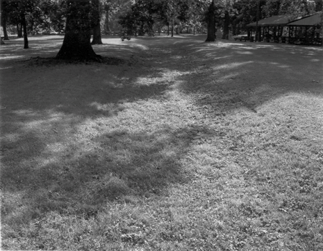
Edwards Trace as it is today.
BARELY A TRACE
What’s left of the Old Indian Trail
known as Edwards Trace
By William Furry
Traffic is brisk on East Lake Drive this
Sunday morning. SUVs pulling sleek outboards flirt with the 45
mph speed limit, hoping to steal seconds from a season fading faster
than the morning mist. Nearby, a white CWLP utility truck dutifully
traverses Lake Park, its crew pausing only long enough to empty the
overflowing trash bins before the day’s activities fill them
again. Even the squirrels are busy at this hour, racing to get
their acorns stored before the first frost.
Yet, not twenty-five yards away, time stands still on
a high ridge overlooking the watershed of what once was Sugar Creek. Here,
beneath behemoth oaks and hickory trees, unassuming in timed morning sunlight,
stretches what several central Illinoisans believe is the oldest human
construction in Sangamon County: a 200-foot remnant
of the historic Edwards Trace.
Named for Illinois Territorial Governor Ninian Edwards
soon after the War of 1812, this former Native-American footpath and later military
road was once the only "highway between Kaskaskia and Peoria, the trail that
brought Springfield’s earliest settlers to the Sangamon River valley.
For all practical purposes, however, it doesn’t
exist. You won’t find it on any twentieth century Illinois map, and
most history books ignore the Edwards Trace. Only a handful of Illinois
historians and archaeologists have studied or followed it, and other than the
fading remnants of the trail itself, there are no signs, nor markers, no dramatic
artifacts
to inform the casual observer of its significance.
Local historian David Brady wants to change that before
there’s no trace of the trace left in Sangamon County. Of course,
that could be years from now. Lake Park is on city property and in no immediate
danger of being developed or altered. But given the city’s
poor track record for historic preservation, and the impending construction of
Hunter Lake, which will forever submerge a great deal of Sangamon County’s
pioneer history. Brady’s not taking any chances.
Prairie sleuthing
History, especially state and local history, is the
never-ending topic of conversation at Prairie Archives, the antiquarian bookstore
on the Old Capitol Plaza in downtown Springfield. Amidst the dusty, leatherbound
volumes of forgotten Illinois lore are stacks of century old newspapers, obsolete
maps, and photographs of things and places that
are no more. It’s a good working environment for David Brady ,
who loves to talk history, especially about Sangamon County and its early settlers. But
Brady doesn’t just sell books and chat about the past. Sometimes he bakes
pies. Last week it was peach. This week it was Cherry. Nobody
complained.
He also gets his hands dirty. Last year the forty-six –year-old
amateur historian self-published a handsome centennial history of Divernon, his
hometown. The book sold out even before the anniversary bonfires had cooled. Folks
who want to know the historyof that colorful community don’t go to the Divernon public library
anymore, they call Brady.
With grizzled beard and ball cap, Brady’s been
a fixture at Prairie Archives for eight years now, almost as long as he’s
been on the trail of the Edwards Trace.
"I’ve been looking for the trace for about nine
years." Brady told Illinois Times. The historic highway ran from
Kaskaskia to Edwardsville to Peoria, Brady noted, "but the section
from Edwardsville to Peoria was the more significant to me."
And he looked hardest in his own backyard.
"I always thought there would be something left along
the timber margin where you would enter or exit a creek—something that
hadn’t been tilled yet." He explained. "but I’ve always
looked further south. If you read early accounts of the trace, settlers mention
turning north at what today would be Farmersville—the headwaters
of Macoupin Creek,
which would have put the trace in Divernon township."
Reading about the trace is one thing, finding it is
quite another. The trail, for instance, was never paved. And as the
state was settled, much of it became private property,. What wasn’t
developed was plowed under, what was abandoned eroded quickly from the landscape.
But before 1830, the Edwards Trace was the only way
to get from Southern to northern Illinois, the most direct route from Fort Russell
(near present-day Edwardsville) and Fort Clark (Peoria). These sites featured
significantly during and after the War of 1812, when territorial governor Ninian
Edwards raised an army to suppress
warring Kickapoos, who had massacred settlers at Fort Dearborn (present day
Chicago) according to one account, Edwards and his army "stumbled into
the splendors of Sangamon County" while on their way to Fort Clark.
Long before Ninian Edwards, however, the trace had a
history, though not so well documented.
"The Indians used it and before that it was probably
used by herd animals—bison, elk, etc.—to get from water source to
water source, and to the salt licks," Brady explained. "There were probably
several trails that eventually were connected into a single continuous trail
that followed the timber line."
The oldest tribes associated with the trace are
those within the Illini Federation, Native Americans who allied themselves with
the French. After the French were forced out of the territory, northern
and eastern tribes that had fought with the English-- Kickapoo, Potowatomie,
and the Sauk and Fox—moved in. Then came the War of 1812. Those
tribes who stood with the British now found themselves at war with the Americans,
and that alliance eventually resulted in the removal of all native tribes from
within the
boundaries of the state.
Tracing roots
Though now archaic, the word "trace" as a noun meaning "a
beaten path through a wild or enclosed region made by the passage of men or beasts:
has a curious derivation. The Oxford English Dictionary ascribes such usage
as exclusively American, nevertheless citing possible roots from the French ("tracer"),
Provencal ("trassa"), Italian ("traccia"), Old French ("tracier") and Spanish
("trasa"). Such mixed linguistic blood is indicative of the
Edwards Trace, which has been used by a variety of ethnic and cultural populations
in its long history.
Certainly the word was common American vernacular in
the Nineteenth Century, as revealed in this passage from Springfield "founder" Elijah
Iles memoirs, Early Life and Times in Kentucky, Missouri and Illinois, first
published in l883. Referring to his first trip into the Sangamon country. Iles
recalled: "From Vandalia we followed the stakes and struck Gov. Edwards’ war
trace, now dim, thirty miles south of the Sangamon river. From this point
we could see the timber of Sugar and Horse creeks, on the head waters of
the Sangamon."
Another Springfield pioneer, Zimri A. Enos, was dead
four years before his article. "The Old Indian Trail, Sangamon County,
Illinois." appeared in the Journal of the Illinois State Historical Society
(1911). Son of another city founder, Pascal P. Enos, Zimri was himself a patriarch
and an old man before he committed his memories of early Sangamon County to paper.
His reason for writing at the time was to encourage
others to share their memories of the trace, which by then had faded from the
public memory. "This trail or trace should, as an interesting matter of history be
definitely established, before all evidence of its location is gone." Enos wrote.
His own memory was quite lucid. A surveyor and
local lawyer, Enos knew the road from Edwardsville to Elkhart Hill, traveling
it several times as a youth and young man. "The line of this Old Indian
Trail was the wagon route of most of the early settlers of Sangamon county, and
is accurately located in the subdivision surveys of townships 9 and 10 north
range 6 west 3rd P.M. made by the U.S. Deputy surveyor in 1818."Enos recalled. And
when his own memory failed, he relied on that of others: "Mr. Joseph Stafford
informs me that when a boy riding in company with a grown brother along the road
on the narrow divide between Horse Creek and Sugar Creek, his brother called
his attention to and pointed out the line of the old Indian Trail a little to
the side of the road."
The high ridge along East lake Drive at Lake Park is
still very visible, and what remains of the trace is remarkable, given the elapsed
time and development nearby.
"What’s there now is an indentation, worn to a
maximum depth of eighteen inches to two feet, approximately six feet wide at
its base and twelve feet at the top." Brady observes. "That’s
pretty much consistent for old roads in this area, according to what I’m
told. A man from Kentucky who studies wagons explained to me recently that
the wheel bases of the wagons used by Illinois’ earliest settlers---who
were mostly from Kentucky—are consistent with the ruts at Lake Park."
It is possible that the trail at Lake Park owes its
formation to another source, but
those most likely to have created it tend to support Brady’s discovery. "We’ve
moved playground equipment in and we haul garbage out, but we didn’t
make that road." said Tom Fanale, superintendent of Lake Services Maintenance
for Springfield’s City Water, Light and Power (CWLP). "About the
only thing we do is mow it." Fanale has worked for the city thirty years. To
the best of his knowledge, the terrain at Lake Park has not been altered since
the park was opened in 1935.
Brady has shared his observations with experts from
CWLP, the Illinois Department of Natural Resources, the Illinois Historic
Preservation Agency, the Illinois State Museum, and the Illinois State Historical
Society. So far, no one has been able to disprove his claim. Every
bit of evidence supports Brady’s findings.
Every site has its secrets
Archaeologist Robert Mazrim of Athens works for the
Illinois Transportation Archaeological Research Project, a program of the University of Illinois’ Anthropology
Department . Mazrim, who helped prepare the "Cultural Inventory" of the
proposed Hunter Lake site several years ago, knows the Edwards Trace perhaps
better than anyone.
As expert on the frontier period in Illinois history
(roughly 1750-1835), Mazrim says he’s "plotted the trace in every township
from Edwardsville to Peoria" " claims he can document European usage of the trace
as early as 1711, when French priests from Cahokia traveled its length to get
to Lake Peoria.
Not all historians believe the French wandered this
far east from their settlements
along the Illinois and Mississippi rivers, but Mazrim knows otherwise.
"The French settlements weren’t to the uplands." Mazrim
explained, "but that doesn’t mean they did not travel this far from the
American Bottoms" But the trace is hundreds— perhaps thousands of
years older than the French period in Illinois history. Michael Wiant,
curator of anthropology at the Illinois State Museum, was astonished and delighted
when he saw what David Brady had observed on the ridge overlooking Lake Springfield. In
addition to the old road bed, Wiant recognized several unusual formations that
piqued his interest.
"I’ve been to picnics in these parks for years
and never really noticed the landscape."
Wiant told Illinois Times. But when he and Brady toured the site together,
Wiant’s eyes were focused at ground level, "My goodness," Wiant recalled
thinking, "these things don’t belong here." He was looking at two
small mounds gently rising out of the grass, not far from the historic roadbed.
Wiant, who has documented and studied prehistoric Native
American mounds throughout Illinois and the Midwest, later returned to the site
to conduct sediment probes and shared his preliminary findings.
"The two rises appear to be incompatible with
the natural landscape." Wiant told IT.
"The soil properties list telling differences in the stratum when you probe from
one side to the other."
Nevertheless, Wiant acknowledges, "nothing at this stage
is conclusive." Without further, more invasive probes, he said, it is impossible
to tell if the rises have historic or even pre-historic characteristics. Both
are possible, perhaps even probable, given other recent discoveries in Sangamon
County.
Topographically speaking, the Airport Site uncovered
on the bluffs above the Sangamon River in the early 1960s was an unremarkable
mound. Wiant noted, yet it turned out to be a remarkable mortuary site from the
Archaic Period (roughly 4,000 years ago). Likewise, the discovery of pre-historic
mounds on the South Fork of the Sangamon River near Rochester several years ago
captured headlines—and stalled a housing development project. Those
mounds, though definitely newer constructions, were nowhere near
as significant as those found near the airport.
But not all mounds are created equal, and some have
secrets we may never understand.
"A few of my colleagues have proposed that Native-American
mounds were more
than just places of internment (Dickson Mounds) or architecture (Cahokia Mounds)," Wiant
said. "Some might have been used to mark trails or signify other landmarks. If
archaeology has taught us anything, it’s that every site has its secrets.
"Consider the (Floyd) Mansberger study of the Lincoln home," he
continued. "Thousands of people have been through that house and hundreds have
studied it, but when they took off the back porch they found a well that had
never been documented.
"We know a great deal about the Native populations that
lived in the lowlands of the
Illinois and Mississippi River floodplains." Wiant concluded, "but the
upland inhabitants are still a mystery to us. Every discovery raises
many more questions. We have a long way to go before we understand what’s
happening here."
In addition to the "rises," as Wiant cautiously refers
to the, there is at least one other archaeological "hotspot" at Lake Park: the
outline of what appears to be the foundation of a dwelling. Whether the structure
is from the modern, historic, or prehistoric period is impossible to determine
without further exploration, something neither the city nor the state has committed
to do. But historians know for certain that many of Sangamon County’s
earliest settlers "squatted" along Sugar Creek, and that many dwellings were
erected alongside the Edwards Trace. An entire catalogue of these sites
was published in the l994 Hunter Lake study, a document that today is a rare
as remnants of the trace itself. What little physical history is known
about the area will be forever lost once construction begins on Hunter Lake.
Marking the trail
The documented history of the Edwards Trace could fill
a book, if not several. Surprisingly, none has been written. But slowly and surely, the last
vestiges of the trail are disappearing from the landscape. An 1882 history
of Madison County recorded that "county authorities laid out and opened a road
from Edwardsville to Clear Lake on the Sangamon, a distance of seventy miles,
as early as 1820, surveyed by Jacob Judy, who caused mile posts to be erected
along the entire length of the said road, which is known to our readers as
the ‘Springfield ‘ road." Those roadside markers, like much
of the trace,
are gone forever.
Sally Cadagin, president of the Sangamon county Historical
Society is hopeful that with renewed interest about the Edwards Trace, fueled by Brady’s recent
discoveries, the city and county will get behind efforts to mark and help preserve
the site. "This site is really important to the history of our county," Cadagin
said. "So much of the trace has
been lost or destroyed, and we have perhaps the best example of it anywhere
in the state.
"What’s surprising is that there are no other
markers for this historic road anywhere in Illinois." Cadagin continued. "We
need to preserve what‘s left of the trace, not just for ourselves but for
the rest of the state."
Although he has not yet seen the site, historian James
E. Davis, author of Frontier Illinois (l998), Indiana University Press)
called the Lake Park remnant of the Edwards Trace a "potential gold mine."
"If this is truly a segment of the trace, Davis said,
it is an "incredibly rich storehouse of knowledge" waiting to be unlocked.
That kind of talk suits David Brady just fine. Nevertheless,
he’s taking his own action toward protecting the site. Brady is working
with the Illinois State Historical Society, the Sangamon County Historical Society,
and CWLP to have a marker placed in Lake Park. The ISHS maintains more
than 350 historic markers throughout Illinois, from Fort Massac to the Galena
lead mines. This would be the first marker for the Edwards Trace in the
state.
But Brady knows that raising a marker is the least that
should be done. Protecting the
site for future historians and archaeologist to study is far more important,
and the sooner done the better. That will take time, effort, and not
a few bake sales. Fortunately, Brady already makes a great cherry pie.
Former Illinois Times editor William Furry is the
director of the Illinois State
Historical Society.
|